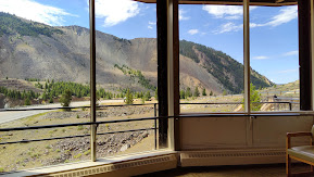
While campers were nestled in their sleeping bags in a campground at the foot of this mountain just outside of Yellowstone National Park, a massive 7.2 earthquake caused a 80 million TON landslide, effectively sheering off the entire side of the mountain as seen here from the visitor center observation window!
Twenty-eight people lost their lives that August night, many buried in the slide at the Rock Creek Campground. The loss of property was also significant as the landslide dammed up the Madison River, flooding an entire valley. Today you can see the "newly formed" Quake Lake, with the remnants of dead trees and houses still present throughout the area.
I had visited here back in 2017. Since it was on my way home from Virginia City a couple of weekends ago, I stopped at the visitor center again. Unbeknownst to me, it was the anniversary week of that fateful night. Watching the documentary video stirred deep emotions, listening to firsthand accounts from survivors who lost family members . . . including parents and siblings.
You can walk through the forest where you can visibly see how the land shifted and "dropped" some 20 feet due to the earthquake. I would also suggest a drive along the river, as it is very pretty with anglers often in the river fishing for trout.
This area is about 30 miles from West Yellowtone, MT and the west entrance into Yellowstone National Park. For anyone who is looking for an interesting day trip, I would highly recommend this as something to do.


No comments:
Post a Comment